
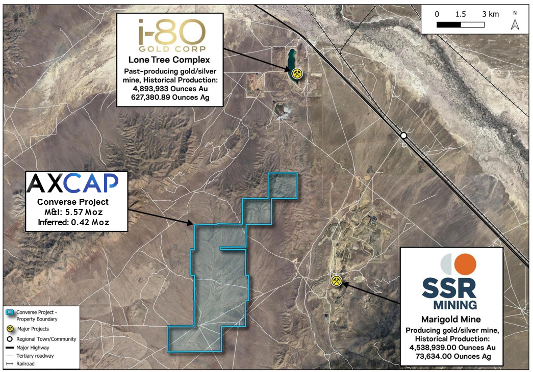
Converse Gold Project
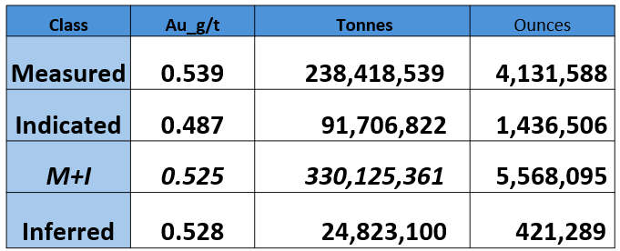
5.57Moz Au M+I plus 0.42Moz Inferred gold resource in Nevada
The Converse Gold Project is the largest undeveloped gold deposit not owned by a major mining company in Nevada -America's premier mining state.
The project is located within the prolific Battle Mountain trend and counts with 5.57Moz of M+I gold resources and a further 0.42Moz of Inferred gold resources.

Mineralization
- Au-Cu skarn deposit associated with the Redline stock. Mineralization occurs within the adjacent Havallah sedimentary rocks and is associated with variable prograde and retrograde metamorphic assemblages
- Disseminated Au-Cu mineralization associated with liberated gold, Fe oxides, chalcopyrite and pyrrhotite widespread over a 1,280m by 640m area.
- Surface oxidation of the system occurs to variable depths


Exploration Upside
- Additional upside through future exploration
- Outside of the existing block model, exploration upside at the Redline deposit is interpreted to mostly exist at depth, which remains open
- Property-scale exploration potential may exist in the lower plate rocks for Carlin-type mineralization
Notes:
1. Mineral Resources have an effective date of 13 February 2025. Mr. Mohan Srivastava, of RedDot3D Inc., is the Qualified Person responsible for the Mineral Resource estimate.
2. Mineral Resources are not Mineral Reserves and do not have demonstrated economic viability.
3. Mineral Resources are the portion of the Redline North and Redline South deposits that have reasonable prospects for eventual economic extraction by open pit mining method and processed by gold heap leaching.
4. Mineral Resources are constrained oxide, sulfide and mixed mineralization inside a conceptual open pit shell. The main parameters for pit shell construction are a gold price of US$2,000/oz gold, variable gold recovery for oxide, mixed and sulfide mineralization, open pit mining costs of US$2.00/tonne, heap leach processing costs of US$4.50/tonne, general and administrative costs of US$1.00/tonne processed, pit slope angles of 36deg for alluvium and 41deg below base of alluvium, a US$2.50/oz refining cost and a 6.0% royalty.
5. Mineral Resources are reported above a 0.006 oz/ton (0.2 g/t) gold cut-off grade. This is a marginal cut-off grade that generates sufficient revenue to cover conceptual processing, general and off-site costs given metallurgical recovery and long-range metal prices for gold and silver
6. Units are provided in imperial and metric.
7. Numbers have been rounded as required by reporting guidelines and may result in apparent summation differences.
8. The QP is not aware of any environmental, permitting, legal, title, taxation, socio-economic, marketing, or political factors that might materially affect the development of these mineral resource estimates.

Permitting
- Permits in place for 50 acres of surface disturbance for exploration
- No known environmental impediments to advancing permitting of an open pit mine
Infrastructure
- Allowance for incoming transmission line and tie-in to the National Grid, on-site substation and emergency generators, as well as for water well field and pumping systems
- Sufficient water rights in place for future mining operations
Newton Gold Project
0.84Moz Au Inferred in British Columbia
LOCATED IN A PRECIOUS METALS DEVELOPMENT DISTRICT
The Newton property is located approximately 100 km west of the city of Williams Lake in central BC within a region characterized by plateau lands with gently rolling hills and other characteristics favourable to project development. The district is well served by existing transportation, power, infrastructure and a skilled workforce which support numerous operating mines as well as late-stage mineral development and exploration projects. Conditions are excellent for year-round exploration and development activities.
- ~180 km south of Artemis’ Blackwater Project (11.9M oz Au and 128M oz Ag)
- Blackwater was acquired from Newgold for $120M IN 2020
- Blackwater is permitted and in development to produce in 2024
- 50 km northeast of Taseko Mines Prosperity Deposit
(13.3M oz of Au & 5.3B lbs Cu)

PROJECT OVERVIEW
UNRIVALED PRECIOUS METALS PROJECT UPSIDE
34,000m drilled in 128 total drill holes
Drilled by previous owner, Amarc Resources Ltd. Explored and developed the resource during 2009 - 2012.
24,000+ Ha
Newton Gold Project encompasses more than 24,000 Ha, the deposit contains 861,400 oz Au & 4,678,000 oz Ag (Table 1-1).
Current resource occupies only 7% of the know IP anomaly
The IP anomaly measures 4 km x 2 km, covers an area greater than 7 sq/km – yet the current resource occupies slightly over 0.5 sq/km or just 7% of the anomaly

Notes:
1. CIM Definition Standards for Mineral Resources and Mineral Reserves (May 2014) and CIM Estimation of Mineral Resources and Mineral Reserves Best Practice Guidelines (November 2019) were used for mineral resource estimation.
2. Recovery factors used are 92% for Au and 45% for Ag.
3. metal prices used are US$1900/oz for Gold and US$25/oz for Silver
4. O’Brien, M.F., (2022) Technical Report on the Updated Mineral Resource Estimate for the Newton Project, central British Columbia
Alteration Types
The alteration types and metal associations at Newton are nearly identical to those epithermal gold deposits in British Columbia – including the large Blackwater, Prosperity, Brucejack and Snowfields deposits
Epithermal Gold
The Newton Gold Project is a large, low - to intermediate-sulphidation, epithermal gold deposit that formed at about 72 Ma (Re-Os date by McClenaghan, 2012), contemporaneous with felsic volcanic and intrusive rocks emplaced into a rifted, structurally-active graben
Gold Mineralization
Gold mineralization is predominately hosted by Late Cretaceous felsic volcanic and intrusive rocks but also occurs in mafic volcanic and clastic sedimentary rocks and along fault and fracture zones
Strong quartz-sericite
Gold and associated base metal mineralization precipitated in extensive zones of strong quartz-sericite alteration
CROSS SECTION OF THE NEWTON DEPOSIT
Consistent mineralization from top to bottom

RESOURCE UPSIDE OF EXISTING DEPOSIT
- Northern portion of resource has multiple gold grades in excess of 1 gpt
- Hole spacing prevents intersections from being incorporated into current resource
- Room to expand outside of current resource pit shell
- High grade intervals marked as waste in resource
- Multiple high-grade intersections exist outside of the current resource
- Strong continuity of high grade within main zone
- Felsic volcanic host rock was encountered nearly the entire 1,001 meters to depth which historically hosted all the gold and silver credits
- 1- Phase 1 drilling tested unchartered open at depth 500+ meters below the current deposit with a 1,001 meter drill hole

SELECT DRILL INTERCEPTS
FOOTBALL FIELDS OF CONTIGUOUS PRECIOUS METALS ZONES

MAIN ZONE – VEIN STOCKWORKS
- Typically, around 2 gpt Au
- Up to 8 gpt Au
- Ag can reach up to 200 gpt
- Pb, Zn, Mo are present as well
- The IP anomaly measures 4 km x 2 km and covers an area greater than 7 sq/km
- Yet, the current resource occupies slightly over 0.5 sq/km or just 7% of the anomaly

Rattlesnake Hills Gold Project
0.61Moz Au M+I & 0.43Moz Au Inferred in Wyoming
The Rattlesnake Hills Gold Project is located in Central Wyoming approximately 100 kilometres southwest of Casper on the western side of Natrona County. The Rattlesnake Hills Gold Project encompasses the Rattlesnake Hills Gold District nearly in its entirety and is a district scale gold exploration project comprising of 1,573 unpatented lode mining claims as well as 8 Wyoming State mining leases covering an area of approximately 30,400 acres.
Within the Rattlesnake Hills Gold Project, four significant zones of alteration and precious metal (gold and silver) mineralization have been identified that are associated with Eocene age alkalic intrusions at North Stock, Antelope Basin, South Stock and Blackjack. All four zones have been drilled and broad zones of low grade gold mineralization, as well as narrow discrete zones of high grade gold mineralization have been intersected, as indicated by the following highlights:
Below is a graphic comparing similar deposit characteristics, Cripple Creek (Newmont), to Rattlesnake Hills Gold Project.
1.jpeg)
The scientific and technical information contained has been reviewed and approved by Blake Mclaughlin, a “Qualified Person” as such term is defined under National Instrument 43-101 – Standards of Disclosure for Mineral Projects (“NI 43- 101”)


